


Aux sources du Lot

Chabard
Gebruiker

Lengte
12,7 km

Max. hoogte
1295 m

Positief hoogteverschil
336 m
Km-Effort
17,2 km

Min. hoogte
1062 m

Negatief hoogteverschil
336 m
Boucle
Ja
Datum van aanmaak :
2025-07-03 06:12:42.0
Laatste wijziging :
2025-07-03 10:09:00.961
3h55
Moeilijkheid : Gemakkelijk

Gratisgps-wandelapplicatie
 SityTrail
IGN / Geografische instituten
SityTrail Plus
De wereld gaat voor u open
Over ons
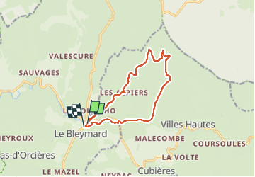
Tocht Stappen van 12,7 km beschikbaar op Occitanië, Lozère, Mont Lozère et Goulet. Deze tocht wordt voorgesteld door Chabard.
Beschrijving
Depuis le Bleymard
Plaatsbepaling
Land:
France
Regio :
Occitanië
Departement/Provincie :
Lozère
Gemeente :
Mont Lozère et Goulet
Locatie:
Le Bleymard
Vertrek:(Dec)
Vertrek:(UTM)
558797 ; 4926589 (31T) N.
Opmerkingen